Before subdivisions and shopping centers transformed the landscape, much of present-day Aberdeen was working farmland (for much of the period discussed here, today’s Aberdeen was known as Matawan Township). Fields, orchards, poultry yards and farmhouses stood along roads that now carry residents between their homes, schools and stores. Edgemere Heights, which contains my residence on Schenck Avenue, was an 18th century farm and orchard worked by the descendants of Middletown Point patriot John Gerritson Schenck (1745-1834) – the original Schenck homestead still stands at 298 Main Street. 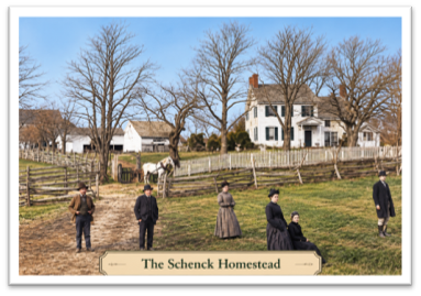 The history of these places belongs alongside the familiar story of the businesses on Main Street in Middletown Point. To understand the community, we need to look beyond its business district to the families who cultivated the surrounding countryside.
That wider view is especially appropriate at harvest time. Farming supplied food, provided livelihoods and connected the area to markets well beyond Monmouth County. The village and its rural neighbors depended on one another. Farmers needed supplies, services and ways to move their produce, while the town’s merchants and transportation businesses benefited from the trade generated by the farms.
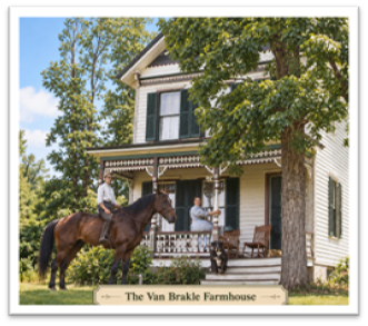 Some of the farming families left names that remain familiar. In Matawan and Aberdeen: Of Town and Field, former MHS member Helen Henderson identifies the Van Pelt and Van Brakle families as substantial landowners in the southeastern part of present-day Aberdeen. William Hyer’s farm lay between their properties, Peter Hyer held 38 acres near Mount Pleasant, and the LeQuier family had a 100-acre farm north of the Van Brakle property. A photo in Helen’s book is of the Van Brakle farm from about 1890, and she advised that the property remained in the same family from 1709 to 2002. Van Brackle Road preserves a visible connection to that long agricultural history.
Another familiar name connects the farms directly to Strathmore. According to Aberdeen historian Ed Fitzgerald’s Aberdeen street-name history paper, Gustave Bechstein purchased the Captain Joe Letson farm in August 1901. After his death in 1912, the property passed to his widow, Adele. Their son William sold the farm to Levitt & Sons in 1961, and Bechstein Drive became part of Strathmore’s Brookview Park section. The same account records that William subsequently lived on the street bearing his family’s name. For residents of that neighborhood, the farm story is part of the history of the ground beneath their homes.
Farming also extended into Cliffwood. A sale notice in the MHS archive appearing in the March 2, 1905, Matawan Journal offered two properties at Cliffwood station formerly owned by the Blenderman Brothers. One contained about 14 acres, a large house and outbuildings. The other held approximately ten acres of fruit and had no buildings. The advertisement promoted the possibilities of a summer residence, illustrating how agricultural property could also attract buyers seeking a country retreat.
The farms varied in size and purpose. The agriculture chapter in Matawan 1686–1936 describes farms in the broader Matawan–Keyport area as generally ranging from 15 to 75 acres, with some larger. Agriculture’s importance came from the combined activity of these properties, rather than from every farm being a vast estate. The account notes that family members often performed the work themselves, with additional help needed during the busy harvest season.
 What did they grow? The 1936 history lists tomatoes, peppers, sweet potatoes, peas, melons, cucumbers and sweet corn among the crops suited to the area. It credits the well-drained soil with helping crops mature early. Apples also reached the market, while smaller grape plots supplied fruit for sale and, in some households, for wine. A photograph in the book shows grapes on the Judson S. Reid farm on Valley Drive (now Route 34). These details offer a more varied picture than fields of grain alone: local agriculture included intensive market gardening, fruit growing and specialized production. The text stated that townsfolk still talked of the quality of the cantaloupes and tomatoes grown in the Matawan area around the turn of the 19th century and sold in New York.
The same account recognizes Italian farmers as important participants in the area’s agriculture, emphasizing the quality and care with which they prepared produce for sale. Their customers included buyers in Newark and New York as well as motorists and neighbors stopping at roadside stands. The book describes regular customers returning year after year. Earlier research identified these farms as present on what is now Church Street in Aberdeen.
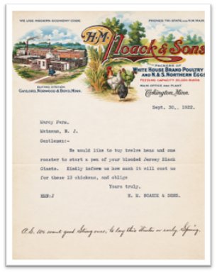 Poultry added another dimension. Monmouth Poultry Farms on Freneau Avenue advertised several breeds, while Marcy Farms became associated with Jersey Black Giants. Surviving Marcy correspondence from 1922, obtained by MHS member Gail Chester, brings this business to life. Prospective buyers asked about breeding birds, hatching eggs, prices and exhibition stock. One writer in British Honduras inquired about shipping birds to Belize by way of New Orleans. (fun fact: a letter dated September 29, 1922, from Leroy Barnett Weeks of The Weeks Mercantile Company, Winter Haven, FL asking for an early delivery of eggs was in the collection. Leroy is my wife’s 4th cousin.)
Other farm names survive in the MHS files. Brookdale Truck Farm was advertised under L. H. Stemler’s proprietorship in a 1908 church bazaar brochure, according to the archive notes. Later recollections place his farm on Middlesex Road near Route 34, in the vicinity of Matawan Auto repair. Old Mill Farm on Church Street is associated with the Dietrich family, while Henderson records Fairlawn Acres Farm on Van Brackle Road selling eggs and poultry with delivery. Together these references show the variety of enterprises that formed the agricultural community.
Getting the harvest to buyers was essential. The 1936 history reports that during 1910–1918, as many as 50 to 75 carloads of vegetables and fruit moved daily from Hazlet and Freneau stations (that figure applies to the two stations and their surrounding producing area, not to Aberdeen alone.) By the time the history was published, it described growers shifting from rail transportation to trucks, using either their own equipment or commercial haulers. The crops still needed markets, but the means of reaching them had changed.
The landscape changed as well. Farms and orchards became increasingly valuable as sites for housing and roads. Henderson describes the transformation along Lloyd Road as Strathmore developed in the early 1960s. The Bechstein property provides one named example of that process. Elsewhere, our archive notes identify William Kuhns’s peach orchard as land sought for construction of the Garden State Parkway. The full history of each property requires its own maps and records, but the larger pattern is clear: fields that had produced food were becoming part of a growing suburban community.
Farming nevertheless remained part of Aberdeen’s life. A Monmouth Conservation Foundation profile traces Samaha’s roadside business to a wagon on Lloyd Road in 1963 and its permanent farm market to 1979. Its continuing presence gives residents a direct connection to the work of growing and selling local produce. It also reminds us that agriculture is more than a vanished landscape recalled in old photographs. The contrast is striking: orchards and farms still survive in neighboring communities, while housing and commercial development have displaced much of the former farmland within Aberdeen. Samaha’s is a rare surviving local link to that agricultural past.
The 1914 Farm and Business Directory of Monmouth County puts names and acreage behind this history. Its listing for Adele Bechstein, widow of Gustave, records 45 acres with a Matawan postal address, corroborating the family’s continuing connection to the farm before the Strathmore development. Other entries include Simon Gavin, a farmer listed with 25 acres and a Cliffwood address, John D. Conover, described as a fruit farmer with 10 acres and a rural Matawan address and Walter Booker, listed as a farmer owning 24 acres with a Matawan address (note: I believe the directory is in error – it’s most likely “Watson” Booker (1843-1923), who had a farm on the site of Lloyd Road School – the marsh behind it is still known as “Booker’s Bog”.).
The same directory offers a sense of agriculture’s countywide scale: its introductory account, drawing on the 1910 census, states that roughly 206,856 of Monmouth County’s 306,560 acres were in farms—about 67.5 percent. While a county figure, it helps explain how thoroughly farming shaped the region at the beginning of the twentieth century.
The harvest story leads naturally back toward Middletown Point. Local records preserve businesses offering seeds, fertilizers, farm implements and machinery repairs. The town and its surrounding farms were linked through these everyday transactions.
Beyond the shops lay the roads and waterways that carried the area’s products outward. Before trucks and railroads took over much of that work, boats connected the farming countryside with larger markets. Our future newsletter with a “maritime theme” will follow that part of the story. For this October, the focus belongs to the fields and the people who worked them—and to Aberdeen’s place in the shared history of our community.
(Author’s note regarding the attached photographs: the farmhouses were restored/colorized using AI. The process does take some liberties with features that are unclear, and I can’t attest to the, say, color of the trim on the Van Brakle home. But the process does bring the images “to life” and they simply look better than the faded B&W pics. The original photos are available on request.)
— Mark Chidichimo
NO COMMENTS